My latest gaming fun is had in Cities:Skylines, by Colossal Order and published by Paradox Interactive. A very nicely done city simulation game where you build the infrastructure (roads, power, water) and amenities (school, police etc) and assign land use – hoping that residents will move in, build their business and enjoy what you have created for them.
Fantastic game
The game is fantastic, the support of 3rd party mods and assets is great and overall I highly recommend it.
Traffic Problems
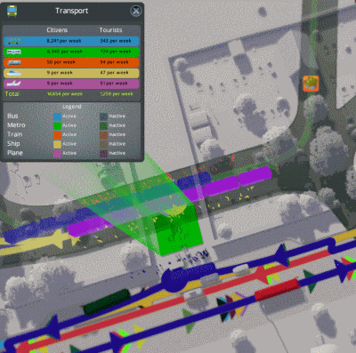
Once my town hit 70.000 inhabitants I became fixated on fixing the mounting traffic problems, so I started to look at my public transport system in more detail. Noticing hundreds of people queuing up at some bus stops seemed like an impossible task to decipher, looking at random samples of the people to see where they were headed seemed inefficient. So when I learnt that I could assign different colors to different bus lines (and rename them) and see how the crowd split between those bus lines, by the color in transport mode, it was a game changer.
I started to create hubs, connected to other hubs with express buses or metro lines. At each hub there would also be local buses, trying to spread the load and make sure no stop had dozens of people that never got to take a bus (and despawned back to their homes after some time). Sometimes I’ve had to create a complementary line to aid a congested one, particularly where big tower flats are numerous.
I’ve by now spent hours on fine tuning the system to eliminate gridlocks, both in general traffic and at bus stations and metro stations. Things seem to flow nicely but I’m still missing several things that would make my life easier!
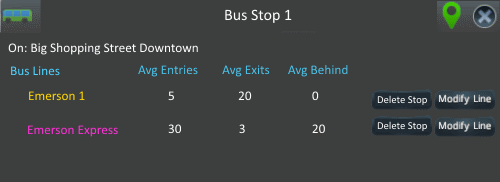
1. Bus stop information
I want to be able to name a bus stop and see which lines use it, how many people exit there and enter on average per bus. From this information screen I would like to be able to delete the stop from a line, using the current interface to do this is very hard as if several lines use the same stop there is no way to pick the correct one. Currently metro stations can be renamed but bus stops not – a generic Bus Stop 1 suffices for default values. My mockup is thus.
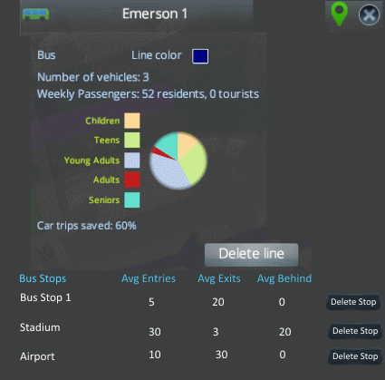
2. Bus line information (and metro)
I want to be able to view the bus line (as is today) but with the stops added and there see average number of entries and exits (and maybe number of people left behind). Similar format for metro lines, although most of mine only go between 2 stops.
3. List of all bus lines, metro lines, metro stations, bus stations
A list of all metro stations for example and what lines they contain. I now have about 30 metro stations and 60 metro lines. Easy to lose track.
4. Name streets
Whilst I would probably not name every little residential street, for the main arteries of my transport system I would like to be able to add names, to aid the in the naming of bus stops, bus lines and metro stations. Again a simple Street 1 as default would suffice.
5. One other thing – the power grid fragmentation
I have an ample power grid now that I’ve got a nuclear plant in addition to the solar and wind gadgets. But a message informing me the power grid had fragmented was of a limited help as I could not see how much power each separate power grid had nor could I color code them to differentiate between them. This would be a welcome help because I’m pretty sure I’m overspending on electricity in some areas.