Vinnustofan fer fram sunnudaginn 17. september – nánari staðsetning auglýst síðar.
Nú í september mætir starfsfólk frá Mapillary til Íslands í vinnuferð. Í lok ferðar ætla þau að halda vinnustofu handa þeim sem eru áhugasamir um það sem þau bjóða upp á – áhugafólk um gervigreind, tölvusýn, götumyndir og samfélagsvirkni ætti að gefa þessu tækifæri.
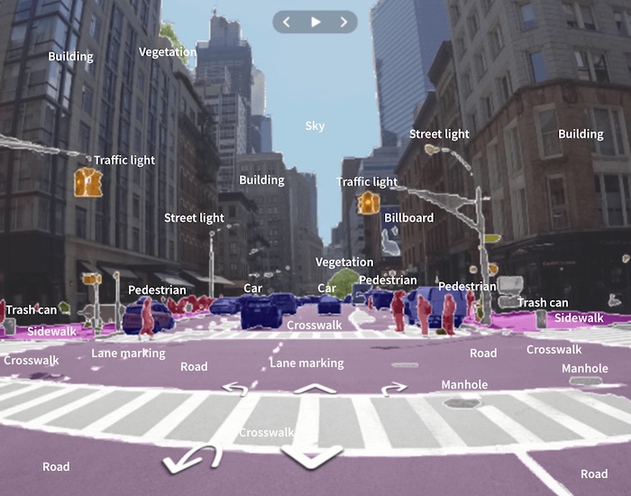
Myndgreining Mapillary
Í grunninn er Mapillary þjónusta áþekk Google StreetView og 360° frá já.is – gallinn við þær þjónustur er hversu sjaldan myndir þar eru uppfærðar sem og að þær sinna bara þeim götum sem þeim þóknast.
Mapillary leysir þetta með því að almenningur getur sent inn sínar eigin myndir með staðsetningu og þannig kortlagt umhverfi sitt sem og breytingar þar í gegnum tímann. Myndirnar eru ávallt frjálsar til einkanota og fyrir hugsjónastarfsemi (non-profit). Göngustígar, hjólastígar, óbyggðaslóðir, almenningsgarðar – hvað sem manni dettur í hug auk gatnakerfisins.
Myndirnar eru svo keyrðar inn í gervigreindarvél Mapillary sem lærir að þekkja þrívíddina í þeim – greinir hjól, byggingar, vegi, veglínur, umferðarskilti og fleira. Þau gögn geta fyrirtæki svo nýtt sér (til dæmis sem punktaský), til dæmis við þróun sjálfkeyrandi ökutækja – gögnin eru svo notuð til dæmis í OpenStreetMap við að kortleggja umferðarskilti og nota upplýsingar þar til að setja inn hámarkshraða, akstursstefnu og fleira.
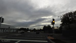
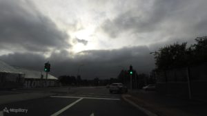
Dæmi um tímaþáttinn er að geta séð þróunina við Dalveg þar sem nýlega voru sett upp umferðarljós. Þessar 5 myndir sýna þróunina, frá því að þar var gríðarleg slysahætta, yfir í framkvæmdir, gátljós og loks umferðarljós. Slík skrásetning getur verið gríðarlega mikilvæg þegar farið er yfir umferðarmál og aðgengismál og auðveldar að benda öðrum á þar sem misbrestir eru, á vettvangi sem allir hafa aðgang að.
Recent postings by Erica Hagen and Gwilym Eades about the colonialism of mapping places remotely have led to some discussion about OpenStreetMap going local only – eschewing remote mapping in all but very rare cases. I find this view of this incredible global project to be in error, furthermore I am creating tools that will make it even easier to find remote places to map – hopefully increasing the number of remote mappers and the amount of remote mapping work done.
Colonialism
I find the premise of these articles to be incredibly narrow, focusing on the emergency response aspect of the map and also somehow managing to make a polygon that represents a building into an imperial construct of oppression.
Now for those who belong to nations that were or are empires it is probably ingrained to be wary of becoming too imperial. For those of us that belong to former colonies no such mental barrier exists, we have been where many nations are currently, they are mere decades behind us in infrastructure and not centuries, as they are in comparison to the empires of past and present. We know the hunger that drives us to get better as quickly as possible, to build infrastructure that aids in the development of our nations and we had no or few adversaries then that tried to hold us back for cultural reasons, fearing we were overextending ourselves and losing ourselves in the process.
To be able to assist others to go further faster, that is something we would have liked to have (and did indeed sometimes receive such help) and so we are puzzled to be accused of imperial land grabs for our efforts.
The articles in question focus on the humanitarian mapping that has been in the news and manages somehow to present what was a boon to people in the field, both locals and those that arrived to lend aid, as an affront to locals and their culture.
The HOSM efforts and missing maps will end up, instead, homogenising that same map forever, westernising it, colonising it, and in effect coopting the last vestiges of autonomy in its creation that remain(ed). Gwilym Eades
How do you manage to colonise a country by displaying its basic infrastructure on a map, a map that makes it easier for locals to get involved and add better local data? How can a building in Botswana be westernized when it is a polygon with the same values as a building in any other continent, if a local adds the detail of its material as mud or straw does it then become Africanized and no longer a colonial subject?
This premise of the articles is indeed the most imperialistic aspect. The self-expression mentioned sounds like any local is a noble savage, and the remote mappers are the decadent civilization encroaching on their territory.
The blank slate
One argument put forward is that by not presenting locals with a blank slate of their home we rob them of their self expression. That is a ridiculous notion as the map can be edited by anyone at a later date, it is also a total opposite of how most people interact with the digital world.
Through my work on OpenStreetMap I have been in contact with locals in many places, both in my native land and abroad. Presenting them with a blank map of their home and telling them they can map it now, using their “own expression”, has not given much result, the percentage of people that see a blank slate that then find the appropriate tool and read up on documentation and experiment is low, evidenced by the low number of original OSM mappers.
The best results in getting locals to contribute has been to map their area remotely and then get them to contribute data, it is easy for most people to see their village on a map and point to where the tavern, healthcare and shop are, they are not creating anything from scratch but adding details to a slate that makes it easier for them to lend their knowledge. By mapping remotely the map is given a leg up.
Some examples are Khawa in Botswana and Eilao in Spain, in both cases I was in contact with a local, showed them that it would be easy to map, got interest but no effort from them due to a technical barrier, mapped the place remotely and showed them again – then receiving feedback that allowed me to add details to the map.
Remote mapping works
The success stories from Liberia and Nepal and past global responses have been many, less known are the umpteen successes that occur every day with the aid of remote mappers on OpenStreetMap in conjunction with local people, foreign and native.
The Peace Corps have thousands of volunteers all over the world and they use OpenStreetMap and remote working to aid in their work as they aid in healthcare for example. An example is the Stomp Out Malaria program, one report detailed how a village in Botswana’s Chobe District was visited by volunteers who checked which houses had been sprayed by using a GPS device and handheld records, then using a base map from OSM to see which places had not yet been sprayed and then with this knowledge they managed to make a plan to revisit places to spray, thereby going from 61,4% coverage to obtaining the 80% threshold that is the minimum recommended coverage.
The base map had been created by remote mappers just days before the visit of the volunteers. This added procedure of mapping was found to be cost-effective and more vitally, enhance the odds of success in combating malaria, a disease that kills hundreds of thousands of people every year, mostly in sub-Saharan Africa and overwhelmingly young children. Just now task #1057 is finishing, Mapping Mosetse, with several benefits for the locals in aiding the locals.
The spirit of OpenStreetMap
More poetically perhaps, I also see maps as representations of who made them rather than a place per se. Erica Hagen
I’m curious as to how remote mapping interferes in the expression of locals. For a map to be global some minimum standardization is required, we use a polygon in the outline of the building to mark it on the map, or a point. We put addresses as attributes of the polygons or as a seperate point inside, or without, a polygon. We do not generally mark addresses as a line between two points although that is possible.
The spirit of OpenStreetMap is not in my mind to stay in your own garden, to mind your own business and not aid in other areas. No project I have participated in has had that expectation of its volunteers, amongst them are Distributed Proofreaders, Project Gutenberg and various Wikimedia projects in a variety of languages.
The spirit of OpenStreetMap is to make a map of the world, including those places that are not commercially viable for other providers and whose population lacks the technology and monetary power to do it themselves. No village left behind.
The mobile world
The number of people that are reaching middle class status in the developing world has been growing and will grow further still, in tens of millions in the coming years. Most of these go mobile and mobile is where editing OpenStreetMap is very much lacking still – not to mention that data charges are still very expensive and lacking in distribution in the developing world, even the developed world.
Try drawing the outlines of buildings on a mobile editor, it will take you an order of magnitude longer to map a village on it rather than using a more powerful desktop editor. Adding smaller items is easier and less of a pain on mobile editors, being able to add points of interest is much more feasible. Totally eschewing remote mapping and telling locals they need to get by on their current hardware using their current connectivity is another example of imperialism in action – leaving the noble savages to fend for themselves.
Remote mapping made easier
I myself did what most others do when they discover OpenStreetMap, I first looked at my local area and improved it. Currently it is pretty much in maintenance mode only, adding or moving POI and on the lookout for buildings being built or torn down. Suddenly my hobby needed more outlets and so I expanded, and expanded more and now I’ve touched the map in dozens of countries.
That was all very random though, zooming in randomly onto the map to find something that was missing, blank slates often and adding something to them.
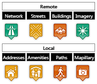
So I’m building a tool, Askja, that makes it easier to improve data where it is lacking. I split it up into two areas, remote and local. Remote mapping is traditional, roads and buildings – the base map. Local mapping is needed for addresses and street names, amenities, paths and Mapillary images.
For each country I add into the tool Overpass is used to get a list of all cities, towns, villages and hamlets. Those are then assigned to regions and subregions using Nominatim. Finally the quality of the current data is evaluated using Overpass and Mapillary APIs, the bot that runs the evaluation checks for roads, buildings, amenities, paths and Mapillary images and marks a scorecard for each settlement.
Scorecard example
The scorecard has 4 different values generally, grey for unknown, red for absence, yellow for partial coverage and green for good coverage. The bot can upgrade network to green status and the others to yellow status automatically. To upgrade anything to green a human is needed to look the area over and pass its judgement. Imagery needs to be evaluated by humans at this point, perhaps that can be automated as well.
So how does it help us to have a list of places that are lacking data – or have data? It makes it easier for the community to find weak spots in their area of interest, whether it is nearby them or not.
The tool is in alpha status – many more features will be added to make it easier for new mappers to find suitable tasks and for niche mappers to find tasks that interest them. We have niche mappers that only like to do the road network, others prefer to map the streets of a village and yet others just want to add buildings or forests or trees.
In addition this approach makes it easier to find quality assurance problems, triplicate settlement nodes (imports gone wrong), settlements that lack names, similarly named settlements within a few hundred meters from each other and more. Not to mention places that are marked as villages but are a tourist campsite, a tavern or otherwise.
Good housekeeping is a part of making a map. Approaching the task of making a world map from many different angles makes the map stronger, it makes the map better.
Everyone needs a map
Today the Western world is used to maps being easy to come by in digital formats, they listen to their smart devices as they use location services from OSM, HERE, Google, TomTom and other providers. They are the base that companies like Uber and FedEx depend on.
The growth potential for communities who are lacking these maps is phenomenal, to withhold that power from huge areas of the world is colonialism, aiding them isn’t.
In addition the locals are not the only people who will need to use a map. Tourists, passers-by, people moving their goods or offering their services also need maps of places where they go. Everyone needs a map even if not everyone wants to make it or use it.
Það er lítið mál að sjá kort fyrir sér sem eitthvað sem breytist lítið, flest okkar áttum við kortabækur sem voru oft orðnar ansi rosknar og líklega má finna Austur-Þýskaland í mörgum bókahillum landsmanna.
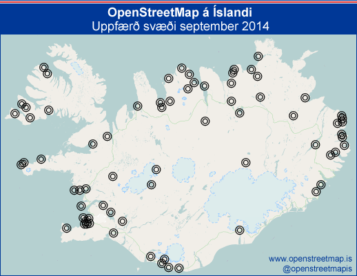
Reyndin er allt önnur, byggingar og hverfi spretta upp eins og við þekkjum, nýjir stígar, brýr og auðvitað fyrirtæki sem birtast og hverfa. OpenStreetMap reynir að gera öllu þessu og fleiru skil. Ég ætla að reyna að taka saman mánaðarlega lífsmarkið sem er á Íslandskortinu.
Hérna má sjá þau svæði þar sem breytingar voru gerðar á Íslandskortinu í OpenStreetMap í september 2014.
Ekki tæmandi listi:
Akranes
Álfaborg
Ásbyrgi
Bakki
Blönduós
Bolungarvík
Borg í Grímsnesi
Borgarfjörður eystri
Borgarnes
Brynjudalur
Brúnavík
Dalabyggð
Dalvík
Djúpivogur
Dyrhólafjara
Eskifjörður
Eyjafjarðarsveit
Eyrarhús
Fimmvörðuháls
Fjarðabyggð
Fálki
Garðabær
Gufuskálar
Gæsavötn
Hafnarfjörður
Hafragil
Hnjótur
Holuhraun
Hvalvík
Hvítárvatn
Hólar
Höfði
Húsafell
Húsavík
Ísafjörður
Knarrarnes
Kópasker
Kópavogur
Langholt
Laugar
Laxamýri
Lárós
Mosfellsbær
Neskaupstaður
Norðausturvegur
Núpur
Ólafsfjörður
Reykjanesbær
Reykjavík
Sauðárkrókur
Selfoss
Siglufjörður
Skaftafell
Skagafjörður
Skógaeyrar
Skógar
Skútustaðir
Svarfaðardalur
Tjörnes
Upphérað
Valdasteinastaðir
Vatnsdalsvatn
Vesturbyggð
Vopnafjörður
Vík
Þingvellir
Þjófadalur
Permalink|Comments Off on Að sýna lífsmark kortagerðar
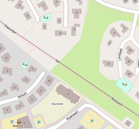
Í gær sunnudag skruppum við feðginin í bíltúr til að prófa fleiri leikvelli. Við settum stefnuna á leikskólann Rjúpnahæð sem er efst í Salahverfi hér í Kópavogi, þar sem við erum með leikskóla í bakgarðinum sem stelpurnar fara daglega á er oft spennandi að heimsækja aðra, sjá hvernig dót er þar og sjá öðruvísi skipulag.
Nú brá svo við að undirritaður hefur verið að fikta í OpenStreetMap (sem er open source útgáfa af einhverju svipað og Google Maps, sumir kalla það wikipediukortið enda geta allir bætt við það sem skrá sig þar inn frítt), hér eftir nefnt OSM.
Leikskólinn Rjúpnahæð er gula svæðið, leikvellirnir eru ljósblá svæði, göngustígar og gangstéttir eru rauðar brotnar línur.
Þar eru leikvellir merktir inn á, ég notaði tækifærið á meðan að stelpurnar skemmtu sér á frábærri lóð Rjúpnahæðar og skoðaði, í BlackBerry símanum sem er með þeim slappari, kortið á OSM og sá þá að tveir leikvellir voru í næsta nágrenni. Þegar nýjabrumið var farið af Rjúpnahæðinni röltum við því á fyrsta leikvöllinn (ljósblár kassi til hægri á kortinu), stelpunum fannst mjög áhugavert að þarna værum við að labba yfir í Reykjavík.
Eftir ágætis stopp þar fórum við aftur á stíginn og ætluðum nú að halda á hinn leikvöllinn, sem er efst á kortinu. Á leiðinni sáum við hins vegar annan leikvöll, lengst til vinstri á kortinu, sem var þá ekki merktur inn. Við stoppuðum aðeins þar og ég setti staðsetningu hans á minnið. Eftir stutt stopp þar héldum við svo áfram upp stíginn og aftur yfir í Seljahverfið og fundum leikvöllinn sem er annars hulinn þeim sem ferðast eftir þessum göngustíg sem aðskilur bæjarfélögin.
Án kortsins hefðum við aldrei vitað af honum, hann er inn á milli húsa.
Við röltum svo til baka með annari viðkomu á nýjasta leikvellinum.
Þegar heim var komið fór ég inn á OSM og merkti inn á stígbút sem hafði vantað á kortið (milli leikskólans og stóra göngustígsins) og nýjasta leikvöllinn. Afraksturinn má sjá að ofan.
Ég hvet fólk til að kíkja á http://www.openstreetmap.org og nota það til dæmis til að finna leikskóla eða leikvelli til að kíkja á með börnin. Ég hvet það enn fremur til að merkja inn á OSM (eða senda mér nótu) ef það sér að það vantar leikvelli þar inn.
Ætla að fara að skoða það hvernig ég get svo birt kort sem sýnir bara leikvelli/róluvelli/leikskóla – hugsa að það verði mjög notadrjúgt um helgar og í sumar!
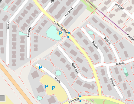
Næst förum við líklega á Hvammsvöll og þessi 6 leiksvæði sem eru þar í kring!
Hvammsvöllur og leikvellir í grenndinni
Permalink|Comments Off on Leikvellir á OpenStreetMap
Það var árið 2009 sem ég kom fyrst auga á OpenStreetMap og gerði tvær breytingar á því, setti svo inn aðra breytingu 2012 og það var ekki fyrr en í ár sem að ég fór að gera eitthvað af viti þar.
OpenStreetMap er sumsé kort af heiminum búið til á svipaðan máta og Wikipedia er skrifuð, af þúsundum sjálfboðaliða. Af hverju er verið að vesenast í svona þegar Google Maps hefur sannað sig fyrir mörgum og fleiri komnir í hituna? Af því að þarna er auðveldara að laga villur og þessi gögn eru í almannaeign þannig að það er hægt að ná í þau og nota í eigin tilgangi. Það er ekki hægt hjá Google og öðrum heldur þarf að greiða fyrir notkun á gögnum þeirra.
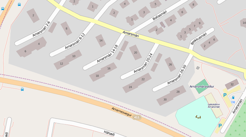
Ég er búinn að vera að teikna Nónhæðarhluta Smárahverfis upp. Það er mjög einfalt reyndar, ég fer á OpenStreetMap, finn þar hverfið mitt og smelli á Edit (það þarf að skrá sig inn, það er ókeypis og auðvelt). Það er hægt að velja um 2 mismunandi ritla til að breyta í vafranum, iD ritillinn þarna er nýr og með mjög góða kynningu á sjálfum sér og hvernig hægt er að teikna á kort.
Þá fæ ég upp loftmynd af hverfinu og tól til þess að teikna upp götur, hús og hvað eina sem er á korti. Sem stendur er ég að vinna í að klára Nónhæðina.
Ég ákvað að bera kortið mitt við ja.is sem notar gögn frá Samsýn. Vinstri myndin er útgáfa ja.is og hægri myndin er útgáfa OpenStreetMap. Á ja.is myndinni hef ég sett nokkra rauða hringi, þetta eru byggingar sem eru ekki til!
Þær eru líklega til á uppdrætti, þetta eru bílskúrar en svo vill til að bara er búið að byggja helminginn af þeim, restin er ekki á leiðinni næstu árin enda þurfa allir sem eiga rétt á að byggja bílskúr að sameinast um það í hverju fjölbýli fyrir sig. Rauði hringurinn lengst til hægri er svo spennistöð, hún er merkt sem Arnarsmári 28a og hefur gert okkur lífið leitt þegar við notum straeto.is því að hann kemur alltaf upp á undan 28.
Samsýn/ja.is nota þarna líklega opinbera uppdrætti, það má sjá að byggingarnar þeirra eru nákvæmari að lögun. En þessir uppdrættir innihalda líka þessar draugabyggingar, það er áhugavert að velta því fyrir sér hvort að heilu draugahverfin séu til á kortum ja.is.
Ég ákvað að skoða þéttbýliskjarna á Íslandi og bjó til lista yfir þá staði sem vantar loftmyndir á og þá sem vantar byggingar á (og hver sem er getur núna farið og bætt við á OSM). OSM-kortið fyrir Ísland á talsvert í land, en í Reykjavík og á mörgum öðrum stöðum stendur það jafnfætis við Google Maps, ja.is og fleiri.
Ég hvet fólk sem hefur gaman af kortum (við erum til og fleiri en menn ætla!) að kíkja á þetta og skoða hvort að það vilji þó ekki nema uppfæra götuna sína, ef ekki meir.